Introduction
On November 17, 2006, we went to Labrador Nature Reserve. The objective was to enhance our learning about Coastal Studies. At there, we see the features that were coastal-related. Not only that, we also recapped what we have learnt for the topic on Natural Vegetation and Weathering.
Coast Profile

Coast is the area between the land and sea.
Shore is the area between the lowest and the highest water level.
Backshore lies between the high water level and the highest water level.
Foreshore lies between the lowest water level and the high water level.
Offshore is never exposed.
Waves
It is the surface of the water which rises and falls when wind blows across the sea.
At Labrador Nature Reserve, we measured the wave period of the wave that breaks at the Promenade and the beach.
Parts of a Wave
Crest is the highest part of wave.
Trough is the lowest part of wave.
Wave height is the vertical distance between crest and trough.
Wave length is the distance between two consecutive crest / trough.
Swash VS. Backwash
White foam that rushes up the shore is the swash, whereas the water that flows back towards the sea is the backwash.
Constructive Waves VS. Destructive Waves
Constructive Waves

- Swash is stronger then Backwash.
- Builds up coasts by deposition.
Destructive Waves

- Backwash is stronger then Swash.
- Erode coast.
Erosional Features

(a) Headland and Bays
Headland is the part of the land that projects out to the sea.(steep rock surface)
Bay is the wide inward curve of land along coast and which compasses part of sea.
Both headland and bay are formed by continual erosion of different resistance rocks. The more resistant rocks erode to form headland, while the less resistant rocks becomes the bay overtime.
(b)Cliffs and Wave-cut platform
Cliff is a steep coastal rock surface.
Wave-cut platform is a gently sloping coastal land surface.

Below is a picture of a cliff at Labrador Nature Reserve.
.jpg)
At the bottom left, part of the cliff has been eroded by the waves.
Now, take a closer look…
.jpg)
When waves attack steep slope at the coast, erosion causes a notch to be produced. It enlarges to become a cave and further erosion of cave result in the overhanging part collapsing, thus the cliff is formed. Continuous erosion of the cliff would result in the cliff retreating inland and a wave-cut platform is formed at the foot of the cliff.
Depositional Features
(a) Beaches
It is an accumulation of eroded materials on the shore when the wave energy is low.
Rocky beach at Labrador Nature Reserve >>>
.jpg)
.jpg)
It is well developed in sheltered coasts, which is a bay between two headlands. Wave refraction causes energy to be dissipated in the bay, resulting in a beach.
Others
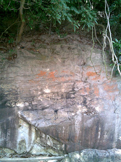
At Labrador Nature Reserve, we have also seen some other aspects of geography like weathering at the dragon teeth gate. We have seen the effects of oxidation on the rocks and the lines of weaknesses between them. Biological weathering also applies there too.
Example of weathering>>>
.jpg)
Also, Labrador Nature Reserve is a tourist attraction and a recreational place. People can be seen at there fishing, jogging, or strolling.
Conclusion
Overall, we have benefited from this assignment. Apart from textbook knowledge, we have observed the coastal shape and learnt how to calculate the wave period. This has helped us to broaden our knowledge on coastal studies. Through experiential learning, we have sure to have shown more interest on geography.
Lastly, we also would want to Thank our geography teacher, Miss Chee, for bringing us to Labrador Nature Reserve for the fieldtrip.
Credits
Snaps are self-taken and diagrams taken from Secondary 3 Interactive Geography Textbook.
Project is done by Group 2.
Group members: Bao Ting, Ivy, Mildred, Nicholas, Xiu Hui, Janet, Yi Rong, Jackie & Rico of 3B’06
PS: All information presented above is mostly according to what is seen during the fieldtrip to Labrador Nature Reserve.

No comments:
Post a Comment