Sunday, December 3, 2006

Group2 -Location2 :Coastal Studies


Introduction

On November 17, 2006, we went to Labrador Nature Reserve. The objective was to enhance our learning about Coastal Studies. At there, we see the features that were coastal-related. Not only that, we also recapped what we have learnt for the topic on Natural Vegetation and Weathering.


Coast Profile


Coast is the area between the land and sea.

Shore is the area between the lowest and the highest water level.

Backshore lies between the high water level and the highest water level.

Foreshore lies between the lowest water level and the high water level.

Offshore is never exposed.


Waves

It is the surface of the water which rises and falls when wind blows across the sea.


At Labrador Nature Reserve, we measured the wave period of the wave that breaks at the Promenade and the beach.


Parts of a Wave


Crest is the highest part of wave.

Trough is the lowest part of wave.

Wave height is the vertical distance between crest and trough.

Wave length is the distance between two consecutive crest / trough.

Swash VS. Backwash

White foam that rushes up the shore is the swash, whereas the water that flows back towards the sea is the backwash.

Constructive Waves VS. Destructive Waves

Constructive Waves


- Swash is stronger then Backwash.
- Builds up coasts by deposition.


Destructive Waves


- Backwash is stronger then Swash.
- Erode coast.


Erosional Features


(a) Headland and Bays

Headland is the part of the land that projects out to the sea.(steep rock surface)


Bay is the wide inward curve of land along coast and which compasses part of sea.

Both headland and bay are formed by continual erosion of different resistance rocks. The more resistant rocks erode to form headland, while the less resistant rocks becomes the bay overtime.


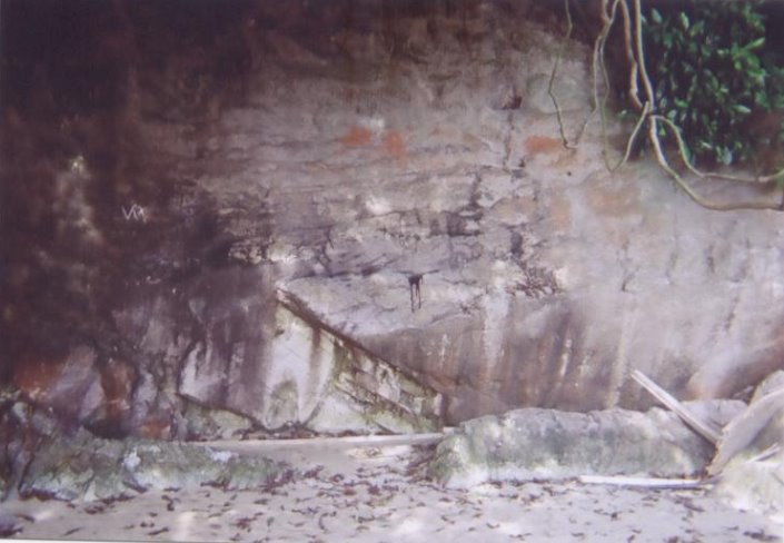
(b)Cliffs and Wave-cut platform

Cliff is a steep coastal rock surface.


Wave-cut platform is a gently sloping coastal land surface.


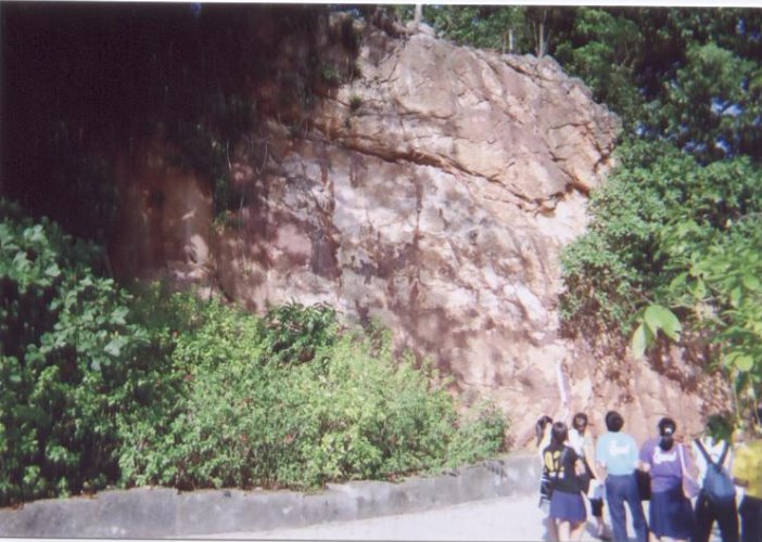
Below is a picture of a cliff at Labrador Nature Reserve.


At the bottom left, part of the cliff has been eroded by the waves.

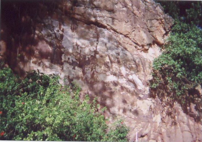
Now, take a closer look…


When waves attack steep slope at the coast, erosion causes a notch to be produced. It enlarges to become a cave and further erosion of cave result in the overhanging part collapsing, thus the cliff is formed. Continuous erosion of the cliff would result in the cliff retreating inland and a wave-cut platform is formed at the foot of the cliff.


Depositional Features
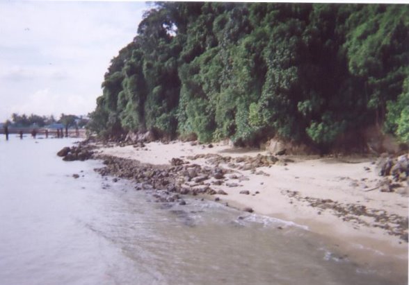
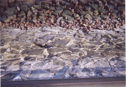
(a) Beaches

It is an accumulation of eroded materials on the shore when the wave energy is low.


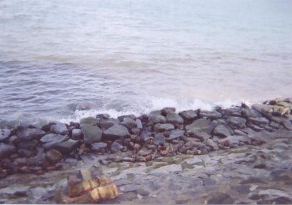
Rocky beach at Labrador Nature Reserve >>>


It is well developed in sheltered coasts, which is a bay between two headlands. Wave refraction causes energy to be dissipated in the bay, resulting in a beach.


Others

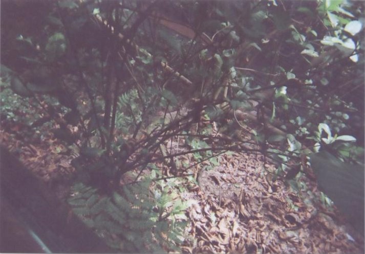
At Labrador Nature Reserve, we have also seen some other aspects of geography like weathering at the dragon teeth gate. We have seen the effects of oxidation on the rocks and the lines of weaknesses between them. Biological weathering also applies there too.

Example of weathering>>>


Also, Labrador Nature Reserve is a tourist attraction and a recreational place. People can be seen at there fishing, jogging, or strolling.


Conclusion

Overall, we have benefited from this assignment. Apart from textbook knowledge, we have observed the coastal shape and learnt how to calculate the wave period. This has helped us to broaden our knowledge on coastal studies. Through experiential learning, we have sure to have shown more interest on geography.
Lastly, we also would want to Thank our geography teacher, Miss Chee, for bringing us to Labrador Nature Reserve for the fieldtrip.


Credits

Snaps are self-taken and diagrams taken from Secondary 3 Interactive Geography Textbook.


Project is done by Group 2.


Group members: Bao Ting, Ivy, Mildred, Nicholas, Xiu Hui, Janet, Yi Rong, Jackie & Rico of 3B’06


PS: All information presented above is mostly according to what is seen during the fieldtrip to Labrador Nature Reserve.


Johans

This trip to the Labrador Nature Reserve was really an eye opener to me,it was not the first time i had visited the reserve but the trip on 17th November really helped me to understand, firstly more about the reserve itself and its history.Secondly,i was exposed to topics that i have learnt in the classroom such as Natural Vegetation, Coastal Studies and Weathering.Lastly,it was also an oppotunity for me to revise on the past chapters that i have learnt so far.

From the reserve,i got to see the different distinct layers of a topical rainforest which i have never taken note of during my past visits.The forest floor was really dense and soil conservation is practised in the area.Roots of trees,properties of leaves and such can be observed from the reserve.

At the jetty,we got to see the wave cut platform as it was low tide at that time and also the coastline.We also had the oppotunity to calculate the wave period by using a stopwatch and observed that waves spill and form white foams.On the beach,we spotted the notch which was expose only during low tide due to erosion of the coast by waves.

At the Promenade,we were able to see how the coast was protected by waves.Sea-walls were spotted at the reserve and serve as a protection against waves.We were also told about swash and backwash.

The last location was the Dragon Teeth Gate,we identified the type of rock that we found there was granite.We were also told that the rock would eventually break down due to oxidation.Lines of weakness in the rock was also spotted that weaken the rock.

Finally,i have learnt to be more aware of our surroundings as geography is all around us,even places like Labrador Park which we usually go there for recreational activities.Therefore to sum up,i would like to say this trip was great learning exprience for me and a beneficial one too.

Nicholas

I used to think that Labrador park is just like any other park you can find anywhere in Singapore. Initially, Labrador park whenever i heard of its name, the impression that will come to me that it is just a war memorial.However, this time i went my impression of it changed, I came to know that it was also a nature reserve.I have gained a clearer picture of what the topics we have learned.

The first area was the aerial tower.The forested area below the aerial tower was similar to the tropical rain forest we learn earlier in the year when we touched on natural vegetation.It is very fascinating to know that there is such a feature in such a urban city like Singapore.I appreciate the efforts of the way environmentalists do to try to prevent the rate of soil erosion.

After climbing down the aerial tower we proceeded to the jetty.It is actually not a beach but a wave-cut platform, although they are look similar.the difference between the both is that wave-cut platform cannot be seen during the high tide while the beach can.There was a cliff over at that area.From the cliff we could see a notch forming at the base of the cliff.The waves that were coming in were all spilling in onto the beach surface.The activity we done there was that we calculated the wave period.That was rather interesting and unique experience as we had never tried before actually counting wave periods.

We then went on to the Promenade.We saw one of the method of coastal protection which was the seawalls.I believe that the walls were built there as the waves heading toward the shore were much more stronger compared to the area where the jetty was.The seawalls will slow down the rate of erosion as when there are stronger waves there will be a larger backwash will lead to a faster rate of erosion.

Finally our last stop was the Dragon Teeth Gate.At the area here we witnessed weathering taking place.The rock there, due to weathering overtime, had turned reddish-brown in colour.So it was obvious that the chemical weathering of oxidation was taking place on the rock.I also could infer from the colour that the rock contained certain traces of iron as oxidation could only occur when there is iron present in the rock.

This trip was one of the few geography field trips that our pure geography class had in the year.It was acting like a reminder to what topics we have learned in the year.I feel that it was more into helping us to recap with the topics that we might not have such a clear understanding upon.And from this experience we have learned not only about the classes we have but also getting to know the environment of little tiny dot country of ours' a little better.

Mildred

Before going to the park, we had learnt about the tropical rainforest in class already, and have seen pictures of it. But it was when we went there that we actually get to see the forest and experience the feeling of being in a rainforest. Though it was hot, but it was a truly enriching trip.
As we walk down the Aerial Tower, we saw many things about the rainforest. We saw the forest floor, which was quite similar from what we learnt. We also saw the leaves, barks. There,we also saw the soil protection.It help to protect the soil from erosion. We also saw the distinct layers of the forest.


We saw a cliff and a wave-cut platform on the bench. There were large rocks too. We saw the oncoming spilling waves that were gentle. All this was what we learnt in class. Also, we learnt to calculate the wave period.
As we walk down the promenade, we saw the coastal protection -seawalls. The waves was stronger there. It was enjoyable walking there as it was very windy. We saw the mark that marks the deep waters too. There were large boulders there too.


At the Dragon Teeth Gate, we saw rocks that was weathered. One of it was going through oxidation.
When we left the place, i had learnt a great deal about coastal studies and weathering.

Janet :)

This is my first fieldtrip to the Labrador Nature Reserve . At first , I had no interest in going to the park . Instead , I feel that it is a wasting time trip. However, after being to the nature reserve, I feel that I had learnt a lot from this trip and gain another trip of experience.

Firstly, we journey down the stairs from the Aerial Tower to the Jetty. In between the journey, we observe a lot of things. The soil conservation they use to secure the soil to prevent soil erosion when rainy days come. From the journey, the nature vegetation of the equatorial climate was clearly pictured into my mind. The 5 distinct layers, the types of leaves, dense undergrowth, lianas and epiphytes, buttress roots and other insects and animals like squirrels. This forest is however, a secondary forest and not a primary forest.

Secondly, we went to the jetty. It is during its low tide and thus we can get a closer distance to the waters. We measured the wave period of the waves that break at the beach by using a stopwatch. We observed that the waves spill and form white foams. The waves are spilling breakers and they are constructive. We also observed the wave-cut platform at the foot of a cliff.

Thirdly, we went to the Promenade. I observed that there is a coastal protection method used to prtect the coast, it is seawalls. Again, at the Promenade, we measured the wave period and there is a difference in the two wave period.The one in the Promenade is lesser than the one in the jetty.

Lastly, we went to the Dragon Teeth Gate. There is signs of biological and chemical weathering taling place there.The evidence from the rocks that there is oxidation taking place as there is reddish-brown iron oxide present on the rock surface.

At the end of the trip we took a photo to prove that pure geo students of class 3b3d 06' had been to the labrador park.

After the trip, I had actually seen the real swash and backwash, lianas, seawalls and others. This is a lesson thst you are unable to learn or see from any of the textbooks and assignments. I hope that there is other fieldtrips avaliable to help us learn more about geography!Lastly , I would like to thank Ms. Chee for this valuable lesson that is taught.

Saturday, December 2, 2006

Lizhong

After the field trip I have learnt more about geography. At the first station, Aerial Tower, I learnt about the distinct layers of a tropical rainforest, the type of vegetations growing in the different layers and the methods used to protect the forest floor. At the second station, Rocky Beach, I am able to witness erosion done by waves to the coast and how these erosion forms the coast. For example, the notch we saw at the coast which was formed due to the erosion of the coast during high tide by the waves. At the third station, The Promenade, we are able to see how the coast is protected from erosion where seawalls are built to prevent strong swash from eroding the coast. Finally at the fourth station, Dragon Teeth Gate, we are able to see how weathering will shape the rocks. For example, we are able to see how rocks containing iron are affected by oxidation and therefore turning the rock to be reddish brown. From this fieldtrip I have learnt how geography is taking place in our actual life and is able to witness it.

Siew Wei

The Labrador Nature Reserve fieldtrip had definitely been an interesting outdoor venture to relate what I have learned in the topic of Coastal Studies, Weathering and Natural Vegetation to the field.
The staircase built on the edge of the secondary forest offer a prime view of the cliff side vegetation coupled with a panoramic view of the cliff. As I journey down the staircase from the Aerial tower where the natural vegetation thrives, to the jetty, I observe the features of the secondary forest and study its characteristics. Many of the tress at there was consider rare. Soil conservation was also done to prevent soil erosion such as mesh netting. A leisurely stroll along the nature trails, different animals and raptors were sighted occasionally such as the squirrels scurrying up trees and the monitor lizards that sun along the foot path.


The Forest The forest floor
Fronting the 30m high cliff sides is the 300metres Labrador beach, extremely rich in marine flora and fauna at the beach. The animals exploit the environment created by an exposed rocky shore. I also observed the patterns of approaching waves as well as the general direction from which they come and lastly how the marine processes that shape the coast at Labrador Park. There was also a wave-cut platform at the foot of the cliff, a result of the continuous erosion at the base of cliff causing the cliff to retreat inland.


The Coastline A wave-cut platform

Walking along the Promenade to the soothing sound of the waves, I identified the coastal protection method used along the Promenade which was the seawall that helped to reflect waves away from coast. I have also seen the motion of the swash and the backwash.


Seawall Swash
The Dragon Teeth Gate shows evidence of different types of weathering that took place, such as physical, chemical and biological weathering. I have also learnt the historical significance of the Dragon Teeth Gate that was used to navigate waters around Singapore in the past.


Dragon Teeth Gate Weathering of Dragon Teeth Gate
I think the activity at the Aerial Tower was the most beneficial as it had inculcate a sense of appreciation and understanding the value of Labrador Nature Reserve as one of Singapore’s nature parks and the importance of preserving the natural environment in our landscape.

What I had observed on the fieldtrip help to make what I have learned in the classroom more relevant and interesting as I was exposed to different modes of assessment to measure my learning. As well as an aid in sustaining my interest in Geography through experiential learning.